Mount Union borough
Dickens on the Canal
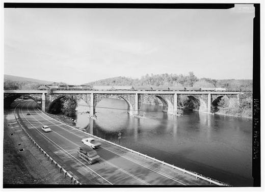
Charles Dickens took a canal boat down the Juniata River in the 1840s, when the waterway was the main road. The canal had replaced the earlier ferries, offering faster passage than the river crossings that came before. In his 1909 history, Charles H. Welch recorded Dickens's own words about the journey: "There was much in this mode of traveling which I heartily enjoyed at the time, and look back upon with great pleasure."
This photograph shows the river Dickens saw. The stone bridge visible here was built in 1906. In Dickens' day, travelers depended on the canal boats to cross.
From the record
Passages about this subject, quoted from county histories now in the public domain. Each one names the book and the position in the text so it can be checked. Spelling is as printed.
Watts, Robert Ferguson, Benjamin Walker, and Joseph Nagle. The names of Stophel Munce, George Etzmiller, Francis Ellis, Samuel Neaves and John Miller appear in the early records as landowners, and some of them may have lived in the township. The Pennsylvania canal ran through this township and the Pennsylvania railroad now follows the Juniata river on the opposite side. The township was named for David Watts, who presided over the court at the time the township was erected in 1849. The first school house was built on what was known as the "Church Lands." It was without a floor and it is said to have settled so much that the teacher could not stand erect in it, when it was rebuilt. In 1912 there were three public schools , McAllister's, Centre, and Livingston's. The schools of New Buffalo, the only borough in the township, are not included in the above. Wheatfield township was erected on January 5, 1826, in response to a petition filed with the court in May, 1824. Several unsuccessful attempts had been made prior to that time to divide Rye township, from which the territory of Wheatfield was taken. At the time it was created it contained 298 taxpayers, but it has since been reduced in size by the formation of Miller, Centre, Penn, and Carroll. Since these townships have been cut off Wheatfield is bounded on the north by Miller, east by the Juniata river, south by Penn, and west by Carroll. It is ten miles long and three miles wide, having an area of thirty square miles.John W. Jordan, ed., History of the Juniata Valley and Its People (New York: Lewis Historical Publishing, 1913) · character 546,114 of the scanned text
William Moore and John Walker were the first tavern keepers, and Dr. Buchanan was the first physician. Alexandria became the western terminus of a stage line to Harrisburg in 1808, and after the completion of the Pennsylvania canal it became an important shipping point. It was incorporated by act of the legislature on April 11, 1827, and in July, 1847, Trimble's addition was made to the original plat of one hundred lots. The town has a good public school building, a public library, handsome church edifices of different denominations and in 1910 reported a population of 432, an increase of 26 over the census of 1900. Birmingham, situated on the Little Juniata river and the main line of the Pennsylvania railroad, seven miles west of Huntingdon, was laid out in December, 1797, by John Cadwallader, "for a manufac- 88 HISTORY OF THE JUNIATA VALLEY turing town at the head of navigation." The proprietor was generous in his ideas of building up a town, donating lots for educational and religious purposes, a "library hall," etc. On the plat, near the bank of the Juniata, was marked "the Public Landing," which was also designated as the "head of navigation." In order to stimulate the sale of lots Mr. Cadwallader sold tickets at fifteen dollars, to draw a lot of two acres suitable for manufacturing purposes, or ten dollars for a regular town lot.John W. Jordan, ed., History of the Juniata Valley and Its People (New York: Lewis Historical Publishing, 1913) · character 221,452 of the scanned text
Robert Dean and Joseph Smith obtained legislhtive authority, March 9, 1797, for erecting a wing-dam. John Canan was authorized by act, approved Feb. 19, 1799, to erect a toll-bridge over the " Frankstown Branch of Juniata River, nearly opposite the said John Canan's mills, where the great road from Huntingdon to the western . part of the country and to Pittsburgh crosses the said branch." This crossing was near Hatfield's Juniata Iron-Works, in Porter township. Charles Smith was authorized by act of Feb. 7, 1808, to erect a wing-dam in the Juniata. He then owned the Huntingdon Mills. Shaver's Creek, from its mouth up to the line of James and John Crawford's land, was declared a public highway by act of Feb. 19, 1800; Tuscarora Creek, from its mouth up to the forks near Morrow's mill, by act of April 4, 1805; and the Little Juniata, from Logan's Narrows to Bell's mills, then Allegheny 1 The Frankstown Branch of the Juniata, throughout its whole navigable course, was made a public highway March 23, 1787, 2 Thomas Whittaker resided on the southwest corner of Fourth and Allegheny Streets, where the Union Passenger Station now stands. John Whittaker, conducted the "Sorrel Horse Hotel" on that corner for many years, commencing in 1817, TURNPIKE ROADS. 31 SEN by act of March 26, 1808. The Ageneie Creek became a highway April 1, 1822, and several other acts relative to smaller yeas were passed in subsequent years.J. Simpson Africa, History of Huntingdon and Blair Counties, Pennsylvania (Philadelphia: Louis H. Everts, 1883) · character 224,428 of the scanned text
Sources
No source list was recorded with this item when it was written. It is shown here as written and has not been re-verified. Treat it as unverified until it has been.
Checked 2026-09-17 · Historic Mount Union collection